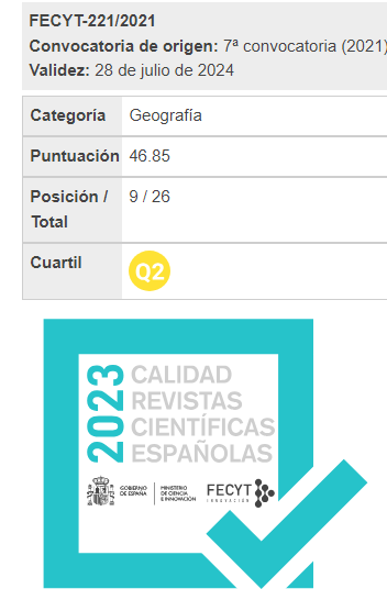
A study and analysis of ways of representing the boundary between adjacent municipal areas as used in different types of maps in Valencia wetland
Keywords:
demarcation, cartography, territory, boundary, municipal areaAbstract
The areas in which local administrations impose their jurisdiction are defined by the lines that divide them from adjacent municipal districts. This implies that if the lines are not clearly drawn it could give rise to conflicts between local councils. It is therefore important that the dividing line be uniformly represented whatever mapping system is used. The existence of discrepancies is detected and analysed in a case study of the municipal boundary line in the wetlands zone of the municipal district of Valencia (Spain), as represented in various maps produced by different organizations during different historical periods.
Downloads
Issue
Section
Articles
License
Los autores que publican en esta revista están de acuerdo con los siguientes términos:
- Los autores conservan los derechos de autoría y otorgan a la revista el derecho de primera publicación, cin la obra disponible simultáneamente bajo una Licéncia de Atribución Compartir igual de Creative Commons que permite compartir la obra con terceros, siempre que estos reconozcan la autoría y la publicación inicial en esta revista.
- Los autores son libres de realizar acuerdos contractuales adicionales independientes para la distribución no exclusiva de la versió de la obra publicada en la revista (com por ejemplo la publicación en un repositorio institucional o en un libro), siempre que se reconozca la publicación inicial en esta revista.